About OkMap Mobile
Record the track of your route as you walk and memorize your waypoints even with photos, to keep the best memories. OkMap Mobile is easy to use and its features are similar to those of the most popular GPS handhelds. Plan...
Record the track of your route as you walk and memorize your waypoints even with photos, to keep the best memories.
OkMap Mobile is easy to use and its features are similar to those of the most popular GPS handhelds.
Plan your routes on the map! OkMap calculates the height differences and travel times for you and produces statistics and graphics.
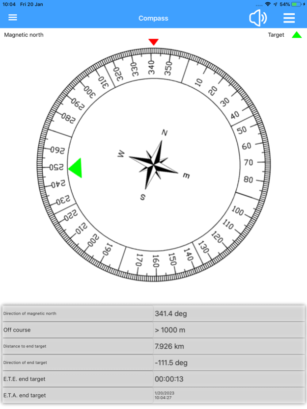
A compass shows you the direction and you will be warned if you are going off course.
OkMap is specially designed for those who do outdoor activities such as search and rescue, hiking, mountain biking, off road, boating, flying, hunting and fishing, mushroom hunting, geocaching, soft air and much more.
OkMap works with different online maps and offline custom maps in MbTiles format.
You can use your favorite digital maps both acquired and scanned!
Furthermore OkMap works with GPX files, the standard format for storing waypoints, tracks and routes.
These files can be copied to and from the PC via cable or via Google Drive.
You can record the track while walking on a trail and/or follow a previously recorded or created track.
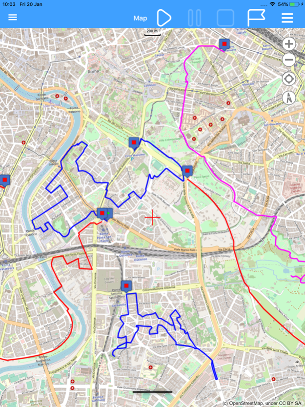
All waypoints, tracks and routes are displayed on the map; the recording track is drawn in real time.
OkMap records the tracks even in standby and with the app closed. A notification alerts you when the GPS is working.
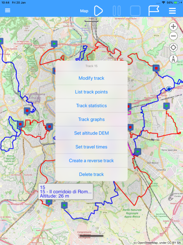
You can create and edit waypoints, tracks and routes directly on the map.
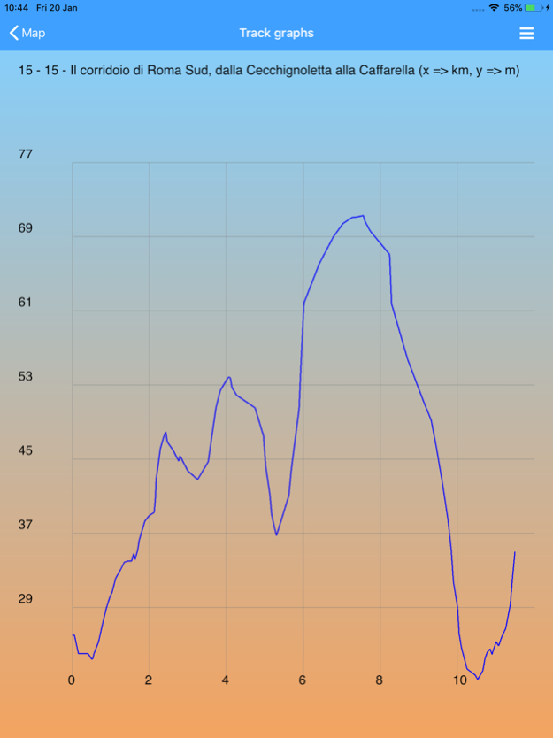
It is also possible to produce different types of statistics and graphs on your own tracks.
Finally, an augmented reality function displays all waypoints with altitude in the device's camera.
FUNCTIONS
Maps
- Offline custom map in MbTiles format
- Online maps from different TMS and WMS web servers (Google, Apple, OpenStreetMap, ESRI, Nokia, etc ...)
- Addition of new custom web servers
- 6 customizable navigation and status indicators (from over 60)
- Coordinates in different datums and formats: Degrees, Degrees-Minutes, Degrees-Minutes-Seconds, UTM, ECEF, OLC, GeoRef, USNG, MGRS, BNG, IG, metrics according to many projections
- Zoom on: GPX data, copied coordinates
- Mode: follow the user's position, distance calculation
- Grids: geographic, metric and DEM data
- Find: waypoint, track, route, address, coordinates
- Reverse geocoding
- Waypoint generation
- Download and management of elevation data (DEM) from the SRTM project
- Integration with: Google Maps, Geocaching.com, Peakfinder.org
- Download waypoints from OpenStreetMap
- Create and edit waypoints, tracks and routes on the map
Navigation
- GPS activation/deactivation
- Start, pause and stop recording of the track
- Stores waypoint at current location
- Navigate to a waypoint and follow a track or a route
- Waypoint proximity function
- Anchor alarm
- Off course alarm
- Sending values via email
- Sending current position and waypoints to a remote OkMap server
Trip Computer
- On-board computer with over 60 navigation and status indicators
Compass
- 6 customizable navigation and status indicators (from over 60)
- Graphic compass with direction of north and destination
- Speech synthesizer when pointing the device
Waypoints, Tracks and Routes
- Lists of various kinds
- Edit and delete functions
- Sorting and filtering functions
- Information detail pages
- Track graphs
- Track statistics
- Track and route inversion
- Automatic attribution of altitudes
- Travel time estimation function
Utility
- List of GPX file
- List of custom maps
- List of downloaded DEM files
- List of web maps
- List of datum
- List of projections
- Preferences
- Reset to factory settings
- Information and links
- Download the online manual
Jan 14, 2024
Version 4.07
EPSG database update to version 11.002.
Added platform in error reporting.
FIX: On iOS the authorization process was stuck on the first page.
Previous Versions
Here you can find the changelog of OkMap Mobile since it was posted on our website on 2023-06-27 18:05:21.
The latest version is 4.07 and it was updated on 2024-04-19 19:59:51. See below the changes in each version.
OkMap Mobile version 4.07
Updated At: 2024-01-14
Changes: Jan 14, 2024
Version 4.07
EPSG database update to version 11.002.
Added platform in error reporting.
FIX: On iOS the authorization process was stuck on the first page.
OkMap Mobile version 4.06
Updated At: 2024-01-04
Changes: Jan 4, 2024
Version 4.06
EPSG database update to version 11.001.
Added authorization process and "Restart the app" message.
AR waypoints: added minimum altitude.
AR waypoints: saving the photo in the album (preferences).
OkMap Mobile version 4.05
Updated At: 2023-11-20
Changes: Nov 20, 2023
Version 4.05
EPSG database update to version 10.096.
New feature: Augmented reality waypoints.
New feature: Preferences: AR waypoints.
Map: Waypoint augmented reality area display.
Minor bug fixes.
OkMap Mobile version 4.04
Updated At: 2023-09-27
Changes: Sep 27, 2023
Version 4.04
New feature: Download waypoints from OpenStreetMap.
First launch: Authorization to use camera and notifications.
Map: Multiline distance: Colors based on visibility.
Preferences - Distance, Area: Visible/invisible distance line attributes.
Preferences - Send OkMap - New indicators.
Added indicators: Sent track points, sent waypoints and failed sends to server.
Minor bug fixes.
OkMap Mobile version 4.03
Updated At: 2023-08-24
Changes: Aug 24, 2023
Version 4.03
EPSG database see 10.093 with datum and projections of the Italian cadastre.
Map: Select up to 3 active maps.
Introduction WMS maps.
List / Insertion of web maps: New layout, test and service functionality.
Web maps list: "Duplication" function.
Preferences - Send data: "Center maps on server".
GPX files, user maps: "Rename" and "Delete" functions.
Minor bug fixes.
OkMap Mobile version 4.01
Updated At: 2023-04-16
Changes: Apr 16, 2023
Version 4.01
Updated EPSG database to version 10.084.
GPS automatic start.
Automatic loading of files opened in the last session.
New map functions: Map orientation, compass, show map points, external services, autorouting.
New GPX functions: export, smoothing, merge, split.
Map server: api key management, previews.
Minor bug fixes.